by Jon Corbett, Christine Schreyer, and Nicole Gordon
“Every language is an old-growth forest of the mind, a watershed of thought, an ecosystem of spiritual possibilities.” — Wade Davis, 2005

View of the Taku River Tlingit Administrative Offices down onto Atlin. Photo: Jon Corbett, 2013
There is a fundamental and synergistic relationship between language, culture, and biological diversity. Within Canada and around the world, Indigenous communities face the parallel losses of these interwoven elements. The past two decades, however, have seen a growing number of grassroots efforts by communities, their advocates, and researchers to reverse this decline and to maintain and restore at-risk languages, cultures, and environments. Here we describe a long-term community-based research project involving investigators from the Taku River Tlingit First Nation and the University of British Columbia, Okanagan. The project seeks to establish whether language revitalization activities that focus on linguistic biocultural knowledge, specifically toponyms, or place names, and whether stories embedded in specific places that can be identified on a map can contribute to increased community involvement in the stewardship of ancestral lands, as well as support language learning.
Since 2012, researchers from both the community and the university have worked directly with the few remaining fluent Tlingit speakers and with Tlingit resource managers and youth in the local school in sharing their place-based stories through a web-based interactive map. In this article, we address how web mapping or geoweb technologies might further expand the community’s ability to re-engage with their Tlingit language through place-based language learning. We also briefly touch on difficulties that we have faced related to the potential appropriation of Indigenous information shared through the geoweb, and we discuss the tensions of balancing the sharing of information to influence positive change with the potential loss of control over this information.
The Taku River Tlingit traditional territory is located in the northwest corner of British Columbia, Canada. The Nation has a population of 374 people. The community’s administrative offices are located in the town reserve called Wéinaa, which in the Tlingit language means “alkali place” and is where caribou come to lick. A number of community members have moved away from Atlin, mainly to the nearby city of Whitehorse in the Yukon, in search of employment and livelihood opportunities. Exacerbating this out-migration, there is no high school in Atlin, so Taku River Tlingit high school students also often move to Whitehorse to complete their studies. As a result of this physical relocation of community members, as well as a large number of other influences, there has been an increasing loss of Tlingit language proficiency.
A 2014 language needs assessment conducted by the community indicated that only two individuals are fluent speakers of Tlingit. Seven individuals understand or speak Tlingit somewhat, and fifty-four individuals are currently learning Tlingit. Furthermore, very few children learn Tlingit at home in Atlin, although programs have been developed to try to reverse this trend through the Tlingit Family Learning Centre (a daycare), the Atlin School, and the Tlingit Culture Camp.
Language is a critical component of culture for Indigenous communities throughout the world. It is the medium through which cultural heritage and biocultural knowledge are passed on between generations. Anchoring language into place through the complex ways in which places are named, and the histories, myths, and knowledge related to those places, is important not only in reaffirming identity and a strong connection to land, but also increasingly in supporting legal claims on that land.
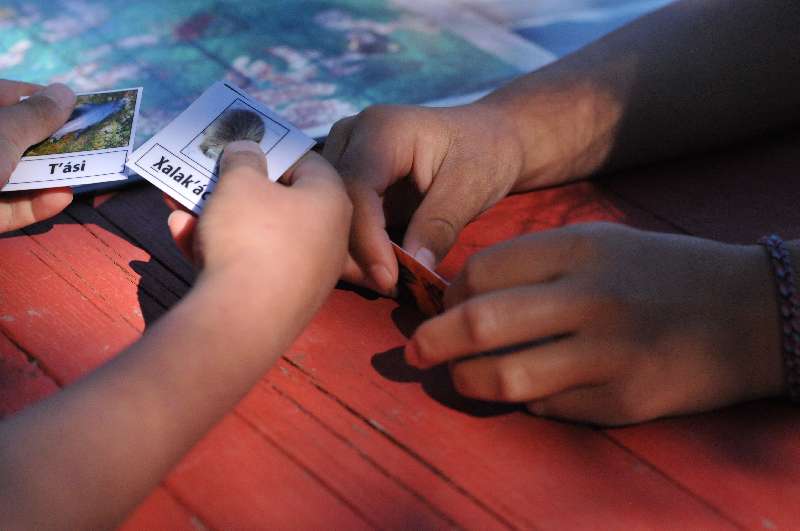
Children use the Tlingit language board game called Haa shagóon ítx yaa ntoo.aat (Traveling Our Ancestors’ Paths) at the Tlingit Culture Camp. Christine Schreyer and Louise Gordon developed the game as a tool for learning Tlingit words for resources and the places where they are located. Photo: Jon Corbett, 2013
The Taku River Tlingit have recognized the biocultural importance of place names for several decades and put emphasis on their documentation as a part of our ongoing community-based research project. Specifically, community members have identified four areas where place names are of particular importance:
1. Names teach you how to respect the land. As community member Andrew Williams describes, “This area with our names on the mountains and our names on the creeks and the rivers, and the lakes, and everything, even on the hills, told a story of the Tlingit use of the land, the Tlingit respect for the land and everything, you know. That’s what I mean, at the end of the story anybody reading it should be able to read it and say, them Tlingits really did respect the land and they really did their best.”
2. Names give you pride. Susan Carlick notes, “I would love for this generation and future generations of young people to be raised to know those names and to not have to be convinced that it’s not a fairy tale, you know, what we tell them about who they are and what their responsibilities are.”
3. Names tell you about the land. David Moss says, “A lot of the Tlingit names were that way because of the use of that land. You know the mountain would have a name that would be specific to the use of that mountain or the area of that mountain and, you know like, Teresa Island. I don’t know who Teresa is, but you know, it used to be Goat Island, right? That gives you a better idea of what’s on that island.”
4. Names let you leave your mark. As Nicole Gordon, the Taku River Tlingit Lands Manager and co-author of this article, notes, “Place names let you leave your mark instead of the English names, and could be used in British Columbia’s land use plan. In terms of Aboriginal Title, place names prove that we were there, and they are a part of our history.”
Place names are anchors of Tlingit language on the land. They are important markers of Taku River Tlingit territory, as well as markers of where Tlingit ancestors used to travel. We also feel that place names, including all of the ecological and biocultural knowledge and stories wrapped up within them, are one of the best ways to begin to relearn the Tlingit language.

To support the documentation of Taku River Tlingit place names, researchers from both the community and the university designed a community-based research project that documents and selectively shares place names, the location of important animals and plants, and stories embedded in specific places. To achieve this goal, we developed and implemented an interactive web-based mapping application. Information is contributed by a carefully controlled set of registered users, comprised of only Tlingit community members and project investigators, and then kept private and accessible only to the person that contributed the information or else shared selectively with either just community members or the public more broadly. The publicly available side of the map can be seen on the project’s website.
Registered users contributed information in multiple formats: photos, audio recordings, video, or text. The information was then associated with a specific location on the territory and represented on the map using a colored map marker. Five themes, or layers, of information emerged on the map after a series of meetings between the research team and the community at large. These themes include the following: place names; Kwéiyi or markings/carvings found throughout the territory; Lingit Kusteeyì or the telling of an important story about the border between Tlingit and Tahltan territory; fish-related information; and finally, Sharing Places, or a layer for community members, and children in particular, to share stories about meaningful places throughout the territory.
To date, a large number of markers have been added to the map, and there is a broad level of support within the community. We have, however, faced challenges relating to fast Internet access in and around Atlin (at present community members have to add information onto the map in the Administrative Offices), arrangement of training workshops in the community, and the physical distance between the community and the university. Also, the community clearly recognizes that the map alone is not sufficient in itself to help revitalize the Tlingit language. As community member Louise Gordon clearly states, “I don’t want to say we’re going to put place names on a map and then that’s it, it’s finished. It’s the beginning.” So, we need to recognize that this type of project is only one small part in a broader community-based strategy to revitalize language through the documentation of place names and associated biocultural knowledge.
We have also learned that we need to be purposeful, as well as a little cautious, about using the Internet as a medium to document and communicate biocultural knowledge. After the project had been running for over a year, we received word that another Taku River Tlingit place names map had appeared on the Internet. We looked at the site and saw that a lot of information on the new map was identical to that on our map. Furthermore, the description of the map implied that the cartographer who made the map had been working directly with the community to create the map. We were perplexed and politely asked the poster to take down the map. He responded immediately, and very apologetically, and noted that someone in the Taku River Tlingit Lands and Resources department had asked him to produce a map that was printable because one of the issues of the interactive web-based medium is that it is not printable. The issue was resolved very swiftly and amicably, but it did make us realize how easily information could be appropriated and repurposed.

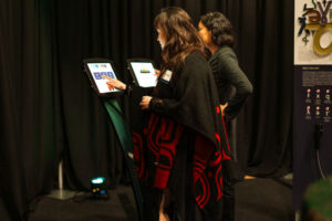
Jackie Williams and Mark Connor review the Lingit Kusteeyì layer on the online map in the Taku River Tlingit administrative offices in Atlin. Photo: Jon Corbett, 2014
Ed Anderson, a Taku River Tlingit community member, states, “I think this particular project is a pretty important step here, and again just telling the world that, you know, this is our land and we have our names on it and this is what the names mean.” However, we clearly need to be purposeful, avoid naiveté, and remain diligent in balancing the sharing of information to influence positive change with the potential loss of control over this information.
As we look to the future for the project, we recognize the need to address these issues. In the short term, we have decided to put a Creative Commons license on the map, as well as a statement about respecting Tlingit intellectual and cultural property in greater detail. For the Creative Commons license, individuals will be able to share the map, but they are required to provide attribution to the Taku River Tlingit First Nation and cannot use the material for commercial purposes, and if they alter the original format for personal use, they are not allowed to redistribute it. As well, the Taku River Tlingit Lands and Resources Department has delegated to a staff member responsibility for approving new users and adding new information to the various layers of the map. She, in consultation with her department and community Elders, will also be responsible for ensuring that the data are appropriate and contributed by community members.
We hope that this will go some way toward ensuring that the community maintains control over the information added to the map in the future and that, in the long term, the community at large will take a level of responsibility to curate the content and accessibility of place names shared through the map.
.
Back to Vol. 4, Issue 1 | Read the Table of Contents | Like Our Stories? Please Donate!
Jon Corbett is a map geek; an Associate Professor at the University of British Columbia, Okanagan campus; and the director of the Spatial Information for Community Engagement lab. All aspects of his research include a core community element: the research is of tangible benefit for the communities with whom he works and that those communities feel a strong sense of ownership over the research process.
Christine Schreyer is an Assistant Professor of Anthropology at the University of British Columbia, Okanagan campus, and an official groupie of the Taku Kwaan Dancers from Atlin, British Columbia. She has worked with members of the Taku River Tlingit First Nation since 2005 when she began a research project with the community about the relationship between Tlingit land, language, and identity as part of her doctoral degree.
Nicole Skaay Dóo.oo is a Taku River Tlingit First Nation citizen from Atlin, British Columbia. She is from the Yan Yeidí clan. Her grandparents are Evelyn and Sylvester Jack. Nicole was raised in Atlin and has a 13-year-old daughter, Evelyn. Nicole has worked for her nation since 2000 and, at the time the article was written, was the Manager of the Lands and Resources Department, a position she held since 2009.
Further Reading
First People’s Language Map of British Columbia. (2014). Taku River Tlingit First Nation Language Needs Assessment. Retrieved from http://maps.fphlcc.ca/node/3152
Taku River Tlingit Place Names. (n.d). Yak’éi yee xwsateení! Welcome! Retrieved from http://trt.geolive.ca